Pushing Boundaries in Utility Consulting

Innovation at NewGen

We develop purpose-driven tools that integrate AI, machine learning, advanced analytics, and industry expertise to address the utility sector's most complex challenges. Our solutions transform big data into actionable decisions.

CCA Rate Comparison tool screenshot
CCA vs. IOU Comparison
NEM 2.0 to NBT Impact
GHG Savings
What-If Scenarios
CCA Analytics · Rate Design

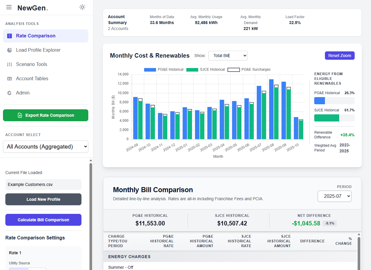
Rate Comparison Tools for CCAs

Our rate comparison platform ingests AMI data directly, enabling Community Choice Aggregators to conduct advanced competitive rate benchmarking analyses for any scenario in minutes instead of weeks. Built for the complex realities of California's evolving energy landscape.

Compare CCA rates to IOU rates side-by-side across all rate classes.
Model the impact of CCA rate changes on customers in real time.
Analyze NEM 2.0 to NBT transition impacts for solar customers.
Recommend the best rate class for each customer profile.
Calculate lifetime savings and greenhouse gas reductions.
View detailed load profiles and run what-if scenarios for load shifting.
Energy · Machine Learning

GridLens

As electric vehicle adoption accelerates, utilities must understand current and future impacts of EV charging on their systems. GridLens uses machine learning and AI to analyze AMI and billing data, identifying EV charging patterns across a utility's service territory without requiring any customer self-reporting or telematics data.

Detect EV Charging

Identify customers charging EVs at home using advanced load-shape analysis and machine-learning classification models.

Geospatial Mapping

Visualize EV charging locations across your service territory, pinpoint infrastructure hotspots, and identify areas of emerging demand.

Track Growth Over Time

Monitor EV adoption trends, forecast future charging demand, and plan infrastructure investments with confidence using historical and predictive analytics.

GridLens tool screenshot
Level 2
Charging Detection
Real-Time
Growth Tracking
GIS
Integrated Mapping
Financial Modeling · Excel

NewGen Financial Model Add-In

Complex utility financial models live in Excel, but managing scenarios, assumptions, and documentation across massive workbooks has always been painful. Our custom Excel add-in transforms how analysts interact with financial models, bringing modern scenario management, optional AI connectivity, and collaboration capabilities directly into the spreadsheet environment teams already know and use. With AI integration, analysts can instantly review assumptions, generate intelligent reports that describe outcomes and scenarios, and surface insights that would otherwise take hours to uncover manually.

Save, Reload & Compare Scenarios

Save and restore scenario configurations with one click, and compare scenarios side by side to understand differences and their downstream impacts.

Assumption Sensitivity

Identify which assumptions drive the most variance in results, focusing analysis where it is most impactful.

Custom Dashboards

Create tailored dashboards that highlight key metrics and outputs for stakeholders.

Embedded Documentation

Store page-level and cell-level documentation within the model to preserve institutional knowledge.

Quick Assumptions Access

Quickly access key assumptions from anywhere in the workbook, reducing time spent searching through tabs.

Optional AI Connectivity

Connect to AI to review assumptions, generate automated intelligent reports, and describe outcomes and scenarios with clarity and depth.

NewGen Financial Model Add-In screenshot

Works Inside Excel

No new software to learn. The add-in integrates seamlessly into existing financial model workflows.

1-Click
Scenario Swap
Sensitivity
Analysis
Excel Online Ready
Impervious Space Detection tool screenshot
Aerial Imagery Input
ML Classification
Parcel-Level Results
Geospatial · Stormwater

Impervious Space Detection

Stormwater utilities require accurate impervious surface measurements to establish fair, defensible billing. Traditional methods are time-consuming and prone to error. Our geospatial tool uses machine learning to analyze aerial imagery and automatically determine the impervious surface area of every parcel in a service territory.

By classifying rooftops, driveways, parking lots, sidewalks, and other hard surfaces from high-resolution aerial photography, the tool provides stormwater utilities an objective, repeatable, and cost-effective way to measure impervious area at scale. This supports equitable billing that reflects each property's actual contribution to stormwater runoff.

Parcel-Level Accuracy

Measure impervious area for every parcel in a service territory with high-resolution precision.

ML-Powered Classification

Automatically classify rooftops, driveways, parking lots, and other hard surfaces from aerial imagery.

Scalable to Any Territory

Process entire service areas efficiently, from small municipalities to large regional utilities.

Defensible Billing Data

Produce objective, repeatable measurements that support equitable stormwater billing.

Let's Build Something New Together

At NewGen, innovation is not a department — it is how we work. We create custom, purpose-built tools that address real challenges for our clients by combining deep utility expertise with modern technology.

Have a challenge that needs a creative solution? Let's talk about what we can build for you.